Showing posts with label kent ridge. Show all posts

Friday, 10 October 2008

The Battle at Pasir Panjang - by Cris

Blogger Cris took time off on the eve of Hari Raya to visit Reflections at Bukit Chandu. He blogged about it and concludes:

I am definitely glad that I had made some time to visit this museum because I have learnt many things. I always have this one sided minded thinking that the only Chinese and Indians fought and sacrificed to protect the country, but the visit to Reflections to Bukit Chandu, has really opened up my eyes and the way I think because the Malays had also done their part in protecting Singapore, just as much as the Chinese and the Indians. That is why racial harmony is very important in Singapore because we cannot afford to be divided in times of war, but be united to protect our very own country till the very end. It was the sacrifice that our forefathers gave, in exchange for a better Singapore in the future, and this is why we have a prosperous nation today.

Read the rest of Cris' detailed post here (blog no longer available).

Tuesday, 9 September 2008

The Pasir Panjang Pillbox


RongC passes by the Pasir Panjang pillbox often and wonders what it was like to have been there during the Battle of Pasir Panjang:

This particular WWII monument certainly had seen its fair share of action; I can picture the scenes some 60+ years ago, with enemy forces creeping around the area and fighters from the Malay Regiment inside the pillbox manning the machine guns and gunning down whoever had approached it on one hand, and worrying that they might be surprised by the sheer numbers of the enemy force on the other hand.

Monday, 12 May 2008

Telok Blangah Hill Park now linked with Mount Faber, Kent Ridge Park

Bridging Ridges


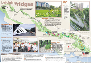
This nice infographic in yesterday's Sunday Times heralds the linking of the Southern Ridges via two bridges. Rather than letting it disappear in archives, we are reproducing it here. (Click to see it full size.)

The Pasir Panjang Guides are familiar with the eastern section of this walk, from the University Cultural Centre at NUS' Kent Ridge Campus to Reflections at Bukit Chandu in Kent Ridge Park. The unmarked road in NUS on the map is Kent Ridge Road. The short section indicated without any greenery - which is inaccurate as there are rain trees and tembusus - is part of Kent Ridge Crescent, leading to a short section of Clementi Road before turning into Clementi Woods Park.

Looks like it's time to whip out those walking shoes!

----------

Sunday Times, May 11, 2008

Two new bridges = a 9km scenic walk
Telok Blangah Hill Park now linked with Mount Faber, Kent Ridge Park

By Teo Cheng Wee

Spanning 274m across Henderson Road, the 36m-high wave-shaped Henderson Waves is Singapore's highest pedestrain bridge. The other bridge, Alexandra Arch, is located in Alexandra Road. -- ST PHOTO: ASHLEIGH SIM
The wet morning yesterday did not dampen the excitement of Telok Blangah resident Habib Ismail.

He was among 500 residents who watched Prime Minister Lee Hsien Loong officially open two pedestrian bridges - Henderson Waves and Alexandra Arch.

With these bridges, Telok Blangah Hill Park is now linked to Mount Faber on one side and Kent Ridge Park on the other.

An avid walker, Mr Habib, 44, a father of two, joined Mr Lee and the other residents on a tour of the bridges.

The bridges complete a 9km chain of greenery in the Southern Ridges, which consist primarily of three large hill parks - Mount Faber, Telok Blangah Hill Park and Kent Ridge Park.

Henderson Waves, at a height of 36m, is Singapore's highest pedestrian bridge. A wave-shaped, steel-and-timber structure, it spans 274m across Henderson Road. The other bridge, Alexandra Arch, spans 80m across Alexandra Road.

Bridging Ridges
The parks were previously separated by roads and wooded vegetation. Now, one can walk ridge-to-ridge, starting from HarbourFront MRT and ending at West Coast Park.

In 2002, the Urban Redevelopment Authority (URA) said it would link up parks in the Southern Ridges as part of the Parks and Waterbodies and Identity Plans.

The project, which took two years to complete, cost $25.5 million.

Apart from the two bridges, the Southern Ridges now also boast the Forest Walk, a 1.3km-long elevated walkway that cuts through secondary forest at Telok Blangah Hill Park; and Marang Trail, which links HarbourFront MRT to Mount Faber.

Mr Lee also officiated the opening of the $13 million Horticulture Park - or HortPark for short.

With 20 theme gardens, HortPark is South-east Asia's first one-stop gardening and lifestyle hub.

The 23ha park, which has been open since December last year, took two years to build and also serves as a park connector between Telok Blangah Hill Park and Kent Ridge Park.

In his speech, Mr Lee noted that such projects 'provide a first-class living environment for all Singaporeans'.

He also announced upcoming plans to link the Southern Ridges to the Keppel Waterfront as part of a broader plan to develop a recreational and leisure hub in the south.

This includes having a park connector from Alexandra Arch to Labrador Park, building a mangrove boardwalk at Berlayer Creek and having a waterfront boardwalk that connects Bukit Chermin to VivoCity, with waterfront views along the entire stretch of Keppel Bay.

Details of these plans will be released soon, the URA said.

About 1 million visitors to the Southern Ridges are expected annually, and with the bridges open 24 hours a day, lovebirds might be expected to make a beeline for them after dark, especially as Henderson Waves offers panoramic views of the city and southern islands.

Mr Habib, a senior research supervisor, had stopped his daily jogs at Telok Blangah Hill Park due to work commitments. He is digging out his sneakers again.

'I'm making plans to walk along the new walk with friends,' he said with a smile.

Monday, 20 February 2006

"I never knew that the ridge was formerly known as 'Pasir Panjang Ridge'."

"Footnotes in Life" reflects on our 2006 Commemorative Walk for the Battle of Pasir Panjang (not the fall of Singapore). Seems incomplete but the fact he learnt abut the Ridge's original name is reassuring for us guides!

"Toddycats." By Footnotes in Life, 20 Feb 2006.

The walk started at a quarter past 7am or something like that, and it started with a briefing telling us what we were going to see and the historical background of the ridge. I never knew that the ridge was formerly known as 'Pasir Panjang Ridge'. The fact that it was a ridge never crossed my mind too. I just thought that NUS was in a strange part of Singapore which was still hilly and haven't been leveled to reclaim more land.

Monday, 5 July 2004

Kent Ridge or Pasir Panjang?

When I first began offering walks on the Ridge in July 2002, I called the series the Kent Ridge Heritage Walks. And offered the walks to the NUS community.

So why this gradual switch to Pasir Panjang?

Well, in order to establish an NUS interest in the walks, our address, Kent Ridge (which I use as "city" when filling in forms), was a useful place to begin with. Few realised the origin of the name, nor that it was only half a century old, and a relative newcomer to the history of the Ridge.

The original name for the area, Pasir Panjang actually means "Long Beach", and isn't unique to the region as many other beaches bear this name (e.g. on P. Bintan and P. Redang).

But it is the name of this ridge and shore behind NUS and its about time I reverted to using it.

And no better time than Heritage Fest.

First posted at Otterman speaks, 05 Jul 2004.

Thursday, 12 February 2004

Kent Ridge heritage


I went for a recce with two others yesterday. It seems the work done on Kent Ridge's Heritage may lead to possibilities for conservation and education.

Several key individuals have recognised the significance and it may all be connecting up now.

One part of this heritage are the four 1939 outposts of Kent Ridge that look to the city, Bukit Timah and Jurong and witnessed the Battle of Pasir Panjang on 13-15 February 1942. We hope to have the public access it in future. Just a little more work now.

First posted on Otterman speaks, 12 Feb 2004.

Thursday, 8 January 2004

Kent Ridge Heritage with NUSSU


On 16th October 2003, a friend in NUS Museums emailed me about introducing a group of NUSSU committee members to Kent Ridge's heritage. She had heard of the RMBR Kent Ridge Heritage Walks so asked to meet up.

So at 3om today, I met the NUSSU group at the Raffles Museum, briefed them and then conducted a short walk. The students were from engineering, science, arts and building and real estate. They were good company and the walk was enjoyable as always. We reached reached Bukit Chandu at 6pm, and my legs were aching for once!

I noticed some changes. There are no more works around what I think was Prince Edward Point (= pt. 270) in NUS, but we cannot access the 1939 outpost. A lot flowers were blooming and good examples of a wide diversity seemed laid out in a just a stone's throw.

The sheltered path to Marina Hill has some panels about flora put up by DSO. At Kent Ridge Park, a photo of the southern islands panorama has been setup at the lookout point (pt 225); most of the islands are identified. And the canopy walk is functional. Oi Yee had mentioned as much some weeks ago.

This year, I will be conducting the walk on Saturday, 14 February 2004, in commemoration of the battle of Pasir Panjang Ridge (11 - 14 Feb 1942).

The area was actually only named Kent Ridge on 3rd October 1952 [actually in 1954]. A faded stone that indicated this was overlooked by most. After a similar session with NUS' OED, they helpfully painted the words of the marble inlay in late 2002 or early 2003. You can't miss it now, and that's where I rendezvous at 5.50am for Marina South bike rides, which is how this day began!


First posted at Otterman speaks, 08 Jan 2004.