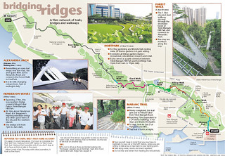
This nice infographic in yesterday's Sunday Times heralds the linking of the Southern Ridges via two bridges. Rather than letting it disappear in archives, we are reproducing it here. (Click to see it full size.)
The Pasir Panjang Guides are familiar with the eastern section of this walk, from the University Cultural Centre at NUS' Kent Ridge Campus to Reflections at Bukit Chandu in Kent Ridge Park. The unmarked road in NUS on the map is Kent Ridge Road. The short section indicated without any greenery - which is inaccurate as there are rain trees and tembusus - is part of Kent Ridge Crescent, leading to a short section of Clementi Road before turning into Clementi Woods Park.
Looks like it's time to whip out those walking shoes!
----------
Sunday Times, May 11, 2008
Two new bridges = a 9km scenic walk
Telok Blangah Hill Park now linked with Mount Faber, Kent Ridge Park
By Teo Cheng Wee
Spanning 274m across Henderson Road, the 36m-high wave-shaped Henderson Waves is Singapore's highest pedestrain bridge. The other bridge, Alexandra Arch, is located in Alexandra Road. -- ST PHOTO: ASHLEIGH SIM
The wet morning yesterday did not dampen the excitement of Telok Blangah resident Habib Ismail.
He was among 500 residents who watched Prime Minister Lee Hsien Loong officially open two pedestrian bridges - Henderson Waves and Alexandra Arch.
With these bridges, Telok Blangah Hill Park is now linked to Mount Faber on one side and Kent Ridge Park on the other.
An avid walker, Mr Habib, 44, a father of two, joined Mr Lee and the other residents on a tour of the bridges.
The bridges complete a 9km chain of greenery in the Southern Ridges, which consist primarily of three large hill parks - Mount Faber, Telok Blangah Hill Park and Kent Ridge Park.
Henderson Waves, at a height of 36m, is Singapore's highest pedestrian bridge. A wave-shaped, steel-and-timber structure, it spans 274m across Henderson Road. The other bridge, Alexandra Arch, spans 80m across Alexandra Road.
Bridging Ridges
The parks were previously separated by roads and wooded vegetation. Now, one can walk ridge-to-ridge, starting from HarbourFront MRT and ending at West Coast Park.
In 2002, the Urban Redevelopment Authority (URA) said it would link up parks in the Southern Ridges as part of the Parks and Waterbodies and Identity Plans.
The project, which took two years to complete, cost $25.5 million.
Apart from the two bridges, the Southern Ridges now also boast the Forest Walk, a 1.3km-long elevated walkway that cuts through secondary forest at Telok Blangah Hill Park; and Marang Trail, which links HarbourFront MRT to Mount Faber.
Mr Lee also officiated the opening of the $13 million Horticulture Park - or HortPark for short.
With 20 theme gardens, HortPark is South-east Asia's first one-stop gardening and lifestyle hub.
The 23ha park, which has been open since December last year, took two years to build and also serves as a park connector between Telok Blangah Hill Park and Kent Ridge Park.
In his speech, Mr Lee noted that such projects 'provide a first-class living environment for all Singaporeans'.
He also announced upcoming plans to link the Southern Ridges to the Keppel Waterfront as part of a broader plan to develop a recreational and leisure hub in the south.
This includes having a park connector from Alexandra Arch to Labrador Park, building a mangrove boardwalk at Berlayer Creek and having a waterfront boardwalk that connects Bukit Chermin to VivoCity, with waterfront views along the entire stretch of Keppel Bay.
Details of these plans will be released soon, the URA said.
About 1 million visitors to the Southern Ridges are expected annually, and with the bridges open 24 hours a day, lovebirds might be expected to make a beeline for them after dark, especially as Henderson Waves offers panoramic views of the city and southern islands.
Mr Habib, a senior research supervisor, had stopped his daily jogs at Telok Blangah Hill Park due to work commitments. He is digging out his sneakers again.
'I'm making plans to walk along the new walk with friends,' he said with a smile.