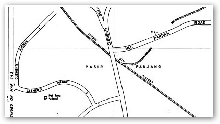
Lam Chun See, at Good Morning Yesterday, asks a question based on a 1980s street directory: Why is Clementi labelled as Pasir Panjang?
As you can see from Chun See's scan (above) the area around Clementi Road and Ulu Pandan Road is labelled thus.
IceMoon, having read Chun See's post, comes up with two possible answers: electoral boundaries or postal districts.
However, he notes that there are issues with both theories.
How big is (or was) the Pasir Panjang vicinity and how was the area demarcated?

3 comments:
To find out how big is Pasir Panjang today, we can look at the cadastral maps from SLA. There is a mukim corresponding to the Pasir Panjang area.
- Icemoon
Hi Icemoon, thanks for replying! Now, I have to ask what 'cadastral' and 'mukim' means...
Okay, before I hit 'Publish', I decided not to be lazy and ask Google: Cadastre and Mukim.
Have you seen Icemoon's explanation at his blog?. I tend to support the electorial boundaries theory.
Post a Comment